


Business hour: 08:30 a.m. to 05:30 p.m. Address: 64, Gongyuan Road, Taipei 100006, Taiwan (R.O.C.) Tel: +886-2-2349-1000
Weather consulting hot line: +886-2-23491234 Earthquake consulting hot line: +886-2-23491168
Reference time: TST (Taiwan Standard Time; GMT + 08:00)
CMT
114 8/18 8:15 ML 5.1 24.02N 121.00E, i.e. 34.5 km ENE of Nantou County
********************************************************************
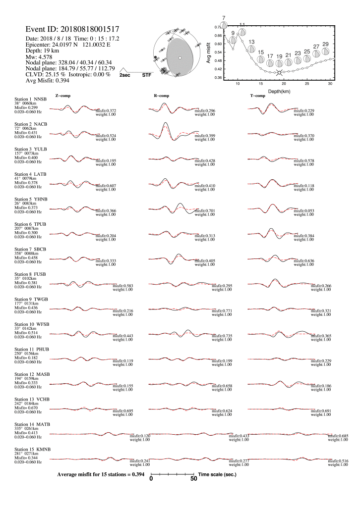
Following is a moment-tensor solution derived from inversion of
CWBSN_BB waveforms. An image file containing all the used waveforms
and misfit distribution with respect to depth.
If you have any questions, please contact seismological center of CWB.
********************************************************************
CWB Early Automatic Report (EAR) :
Origin Time : 2018 8 18 0:15:17.17 (UT)
Hypocenter : 24.02 N 121.00 E 19.11 km
ML : 5.19
CWBSN_BB moment-tensor solution :
-0.0566342 -0.1983154 -0.2782812
-0.1983154 -0.7658803 0.2985808 x 1E+16 Nt-m
-0.2782812 0.2985808 0.8225146
Centroid depth : 19 km
Mw : 4.58
Azgap : 84.58
Average MISFIT : 0.394 (The fit is excellent)
Best double couple solutions :
nodal plane(1) strike/dip/slip: 328.04/40.34/ 60.34
nodal plane(2) strike/dip/slip: 184.79/55.77/ 112.79
#######-----
------##------------
----------#####-----------
----------##########----------
----------#############---------
-----------###############--------
-----------#################--------
-----------##################-------
--------######## ########------
P --------######## T ########------
--------######## ########-----
---------###################----
---------##################---
--------################--
------##############
----########
-
- Earthquake Information
- Disastrous shocks
- Earthquake Report
- Earthquake Factsheets
-
- Tsunami
- Tsunami Information
-
- Disaster Prevention
- Precautions for Earthquake
- Precautions for Tsunami
- FAQ for Earthquake
-
- Observation network
- Observation network
- monitoring station searching
Central Weather Administration Copyright Reserved
![]()